Simplicity for the end-user coupled with a robust background architecture defines fuse.Earth™ in a nutshell. We follow a unique 5-step Geospatial Information Science and Engineering Lifecycle (5GIEL™) in implementing our mantra of “demystifying GIS and empowering the end user”. The 5GIEL™ architecture governs the frontend and behind the scenes of our brand new GIS fuse.Earth™. fuse.Earth™ in entirely cloud-based GIS with five primary components: Geobar™, Geotower™, Geotray™, Geosole™, and Geoframe™ that represent the five key division of the 5GIEL™.

The user adds any and all kinds of geo data through the Geobar™ (including lat, long locations, addresses, shapefiles, KMLs, GIS services as APIs, or raster images from local folders or cloud-based services). Geobar™ has multiple features to add various kinds of data in different formats from various sources, still keeping the data input process simple and straightforward for the end-user.
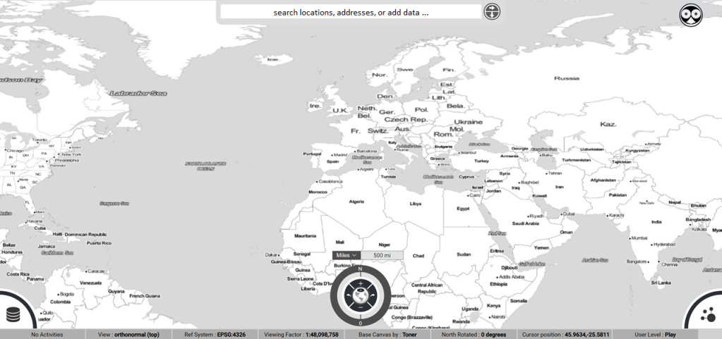

Once the user adds geo data to the fuse.Earth™ system, the data is plotted as layer on the Geoframe™ (the central map display) and a metadata control to this data is added to the Geotower™ (bottom left corner of the screen) as a disc broken down into five categories CSFDI (Connection, Specification, Function, Depiction, and Interaction). The CSFDI™ structure of the geospatial metadata is the most simplified yet comprehensive organization of geo data entirely unique to fuse.Earth™ and Mapsol™. The CSFDI© structure is built for enabling a deeper understanding of the nuances of geo data for the end user yet keeping it simple and enhance easy cognition. The CSFDI©™ structure is educational in that the novice user can easily familiarize herself with the various complex nuances of geo data.
As the geo data becomes available in the system (on Geoframe™ and Geotower™), the user can now implement the tools on the Geotray™ (available in the right bottom corner of screen) to make measurements, run queries, and perform basic spatial analysis. A unique Mapsol™ contribution again, Geopad™ is a map-based communication portal that not only enables data collection (geotagging photos, videos, journals, and other precompiled documents) but simultaneously organizes the collected data projects and topics based on the spatial narratives architecture. All non-traditional geo data created on screen within the fuse.Earth™ system along with any other traditional geo datasets are stored as Geobases™ in our system for easy storage, navigation, and retrieval. The various tools on Geotray™ currently available to user include measurement (distance), querying datasets for geometry parameters and attributes, creating sites and observations on the Geopad™, performing a basic radius buffer vicinity analysis, and sharing one’s work with other collaborators in the form of a “session” that is also unique to fuse.Earth™.

Geosole™ is the key console provided to the user for performing various simple to complex geospatial operations based on the user familiarity of geospatial operations and pedagogical linearity. The simpler side of operations (on the left-hand side ribbon in the bottom center part of the screen) include changing display coordinate systems, understanding/exposing to geospatial (and fuse.Earth™) concepts, adding pre-compiled data services, invoking specialized application dashboards, or browsing through spatial narratives created and shared by other users. More complex operations on the Geosole™ (on the right-hand side ribbon in the bottom center part of the screen) includw creating reference framework definitions, producing geospatial datasets, managing geo data, analysis toolsets, and presentation (map-making) utilities. The bottom central button complex in the Geosole™ is referred to as the Geohub™ and is overloaded with functionalities like zooming in and out, rotating the Geoframe™ (north), a compass tool, changing the view extent based on user history, and showing/hiding the two main Geosole™ ribbons.